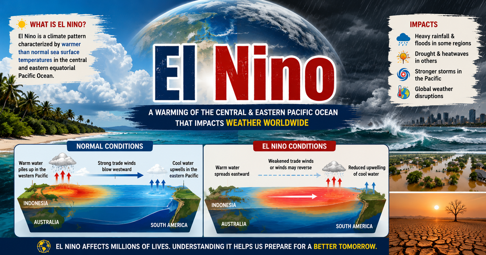
Master El Niño with simple concepts, flowcharts, current affairs, ENSO, Walker Circulation, IOD, Indian monsoon impacts, easy revision techniques, and UPSC Prelims PYQs for better understanding.
Syllabus Areas:
GS I - Geography
GS III - Disaster Management
El Niño is a weather pattern that happens when the Pacific Ocean becomes warmer than usual.
-
This changes winds and rainfall around the world.
-
It can cause heavy rains and floods in some places.
-
Droughts, heatwaves and poor crop production in some places.
Definition
El Niño is an ocean–atmosphere phenomenon of abnormal warming of sea surface temperatures in the central and eastern equatorial Pacific Ocean.
This warming weakens the trade winds, alters ocean circulation and atmospheric pressure patterns, changes global rainfall and temperature distribution
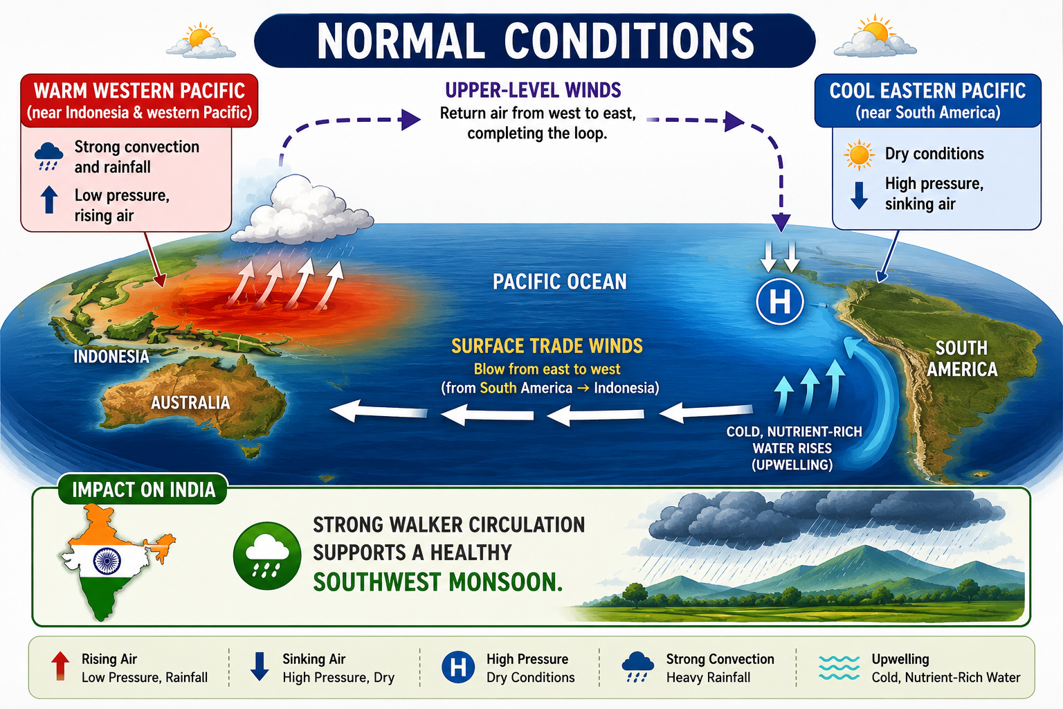
Normal Conditions
-
Strong trade winds blow from East to West across the Pacific Ocean.
-
These winds push warm surface water toward Indonesia and Australia.
-
Cold nutrient-rich water rises (Upwelling) along the West Coast of South America.
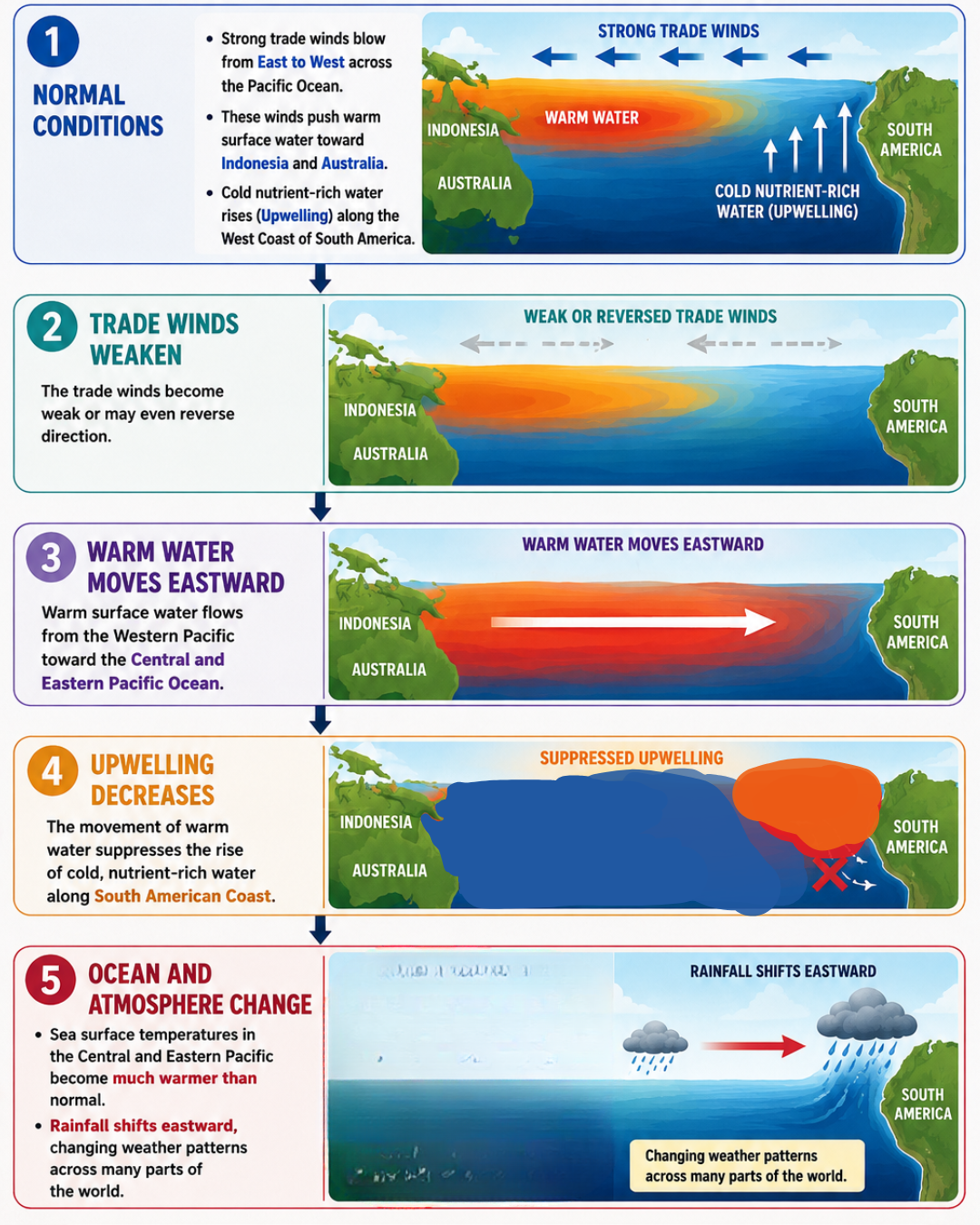
How El Niño Occurs: Step by Step Process
1. Trade Winds Weaken
The trade winds become weak or may even reverse direction.
2. Warm Water Moves Eastward
Warm surface water flows from the Western Pacific toward the Central and Eastern Pacific Ocean.
3. Upwelling Decreases
The movement of warm water suppresses the rise of cold, nutrient-rich water along South American Coast.
4. Ocean and Atmosphere Change
-
Sea surface temperatures in the Central and Eastern Pacific become much warmer than normal.
-
Rainfall shifts eastward, changing weather patterns across many parts of the world.
This phenomenon occurs every 2 to 7 years and lasts 9–12 months.
Walker circulation:
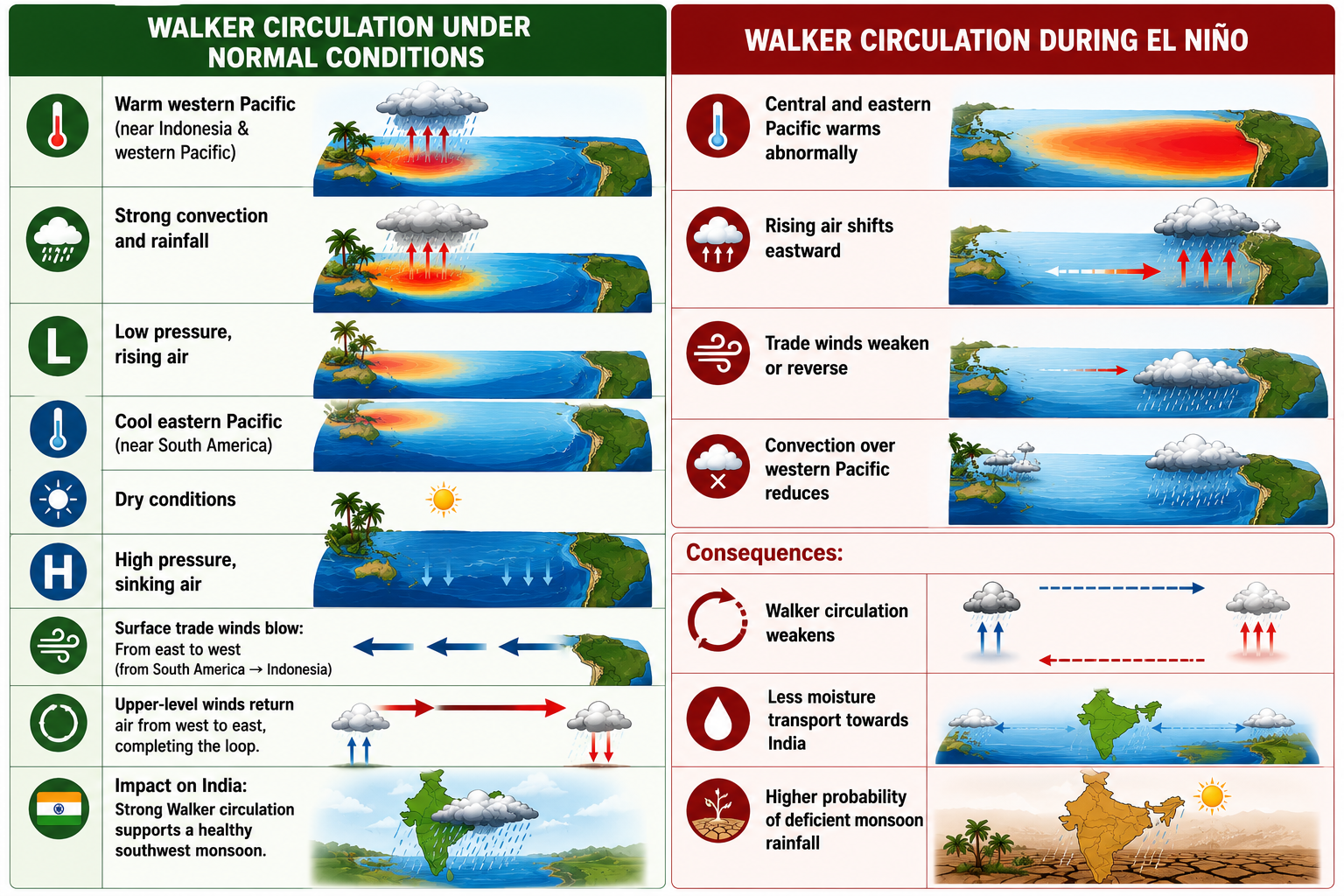
Walker circulation is a large-scale east–west atmospheric circulation that operates along the equatorial Pacific Ocean, and it plays a crucial role in ENSO (El Niño–La Niña) dynamics and the Indian monsoon.
Basic Definition
-
Walker circulation refers to the longitudinal (east–west) movement of air in the tropical atmosphere.
-
It involves:
-
Rising air over warm ocean waters
-
Sinking air over cooler ocean waters
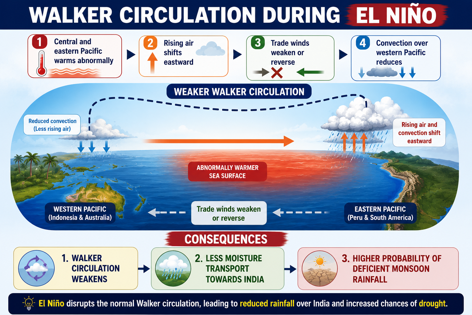
How Walker Circulation During El Niño Disturbs the Indian Monsoon
Step 1: Central & Eastern Pacific Become Warmer
During El Niño, sea surface temperatures in the Central and Eastern Pacific Ocean become much warmer than normal.
Step 2: Rising Air Shifts Eastward
Normally, warm water near Indonesia and Australia causes air to rise there.
During El Niño, the warmest water shifts eastward.
As a result:
-
Rising air and cloud formation also shift eastward.
-
Heavy rainfall moves from Indonesia towards the Central and Eastern Pacific.
Step 3: Walker Circulation Weakens
Since rising air shifts eastward:
-
Air circulation across the Pacific becomes weaker.
-
Trade winds weaken or may even reverse.
-
The normal Walker Circulation gets disturbed.
Step 4: Less Convection over Indonesia
Normally,
-
Indonesia and nearby regions receive heavy rainfall.
-
Strong convection helps maintain the atmospheric circulation that supports the Indian monsoon.
During El Niño:
-
Cloud formation decreases over Indonesia.
-
Less heat and moisture are released into the atmosphere.
Step 5: Less Moisture Reaches India
Because the Walker Circulation is weak:
-
Moisture transport towards the Indian Ocean decreases.
-
The southwest monsoon winds become weaker.
-
Fewer rain-bearing clouds reach India.
Step 6: Indian Monsoon Weakens
As a result,
-
Monsoon rainfall decreases.
-
Rainfall becomes uneven.
-
Many regions experience drought or rainfall deficits.
Gradation of El Niño
A departure of
0.5 – 1°C → Weak
1 – 1.5°C → Moderate
1.5 – 2°C → Strong
> 2°C → Very Strong / Super El Niño
> 2°C crossing threshold happened only a handful records 1972–73, 1982–83, 1997–98, 2015–16
El Niño also follows consistent calendar
-
Starts in one Spring season
-
Peaks in the Winter season
-
Very fast it weakens in the next Spring
Because warming establishes only in Spring.
Several of India's worst droughts were in El Niño years, among them are:
1972, 1982, 2009, 2015
India Rainfall (June 30, 2026)
India by June 30, 2026 logged a deficit of 43% rainfall.
Central India, which comprises most parts of Monsoon Core Zone, the rainfed area where farming depends mainly on seasonal rainfall, recorded highest deficit of 56%.
This will be worse in July–Aug, 2026.
El Niño and Indian Monsoon
El Niño is associated with
-
Weak monsoon
-
Harsher summer in India
The Agri-Ministry has recently mapped as many as 315 districts (40% of total districts in India) as suffering a greater risk of Low rainfall, Shortage of irrigation
Most of these fall in 12 States:
-
MP
-
Maharashtra
-
Gujarat
-
UP
-
TN
-
Rajasthan
-
Karnataka
-
Bihar
-
Jharkhand
-
Telangana
-
Andhra Pradesh
-
Odisha
All 30–80% rainfall deficit
Impact on Kharif Crops
-
In India, El Niño years (2002, 2004, 2009, 2015, 2023) reduced output of key Kharif crops such as Paddy and Maize in more than 140 districts.
-
Though 2023 was also an El Niño year, at that time positive IOD largely offset its impact, helping India get near-normal seasonal rainfall as well as record output of foodgrain.
-
But in 2015, we were not lucky.
Impact on Rabi Crops
-
Since low rainfall in the Kharif season, i.e., South-West Monsoon, results in less water in the country's major reservoirs. Poor moisture content in soil will impact Rabi (Winter Sown) crops during Nov–Feb period.
Other Impacts
-
Drinking water availability is also got affected. Hydropower generation also got affected.
Hence Pranab Mukherjee says, "The monsoon season (June–Sept) is India's True Finance Minister."
Effects on Indian Monsoon:
The two major factors that govern variation in monsoon rainfall, may not help in India.
-
El Niño Southern Oscillation (ENSO)
-
Indian Ocean Dipole (IOD)
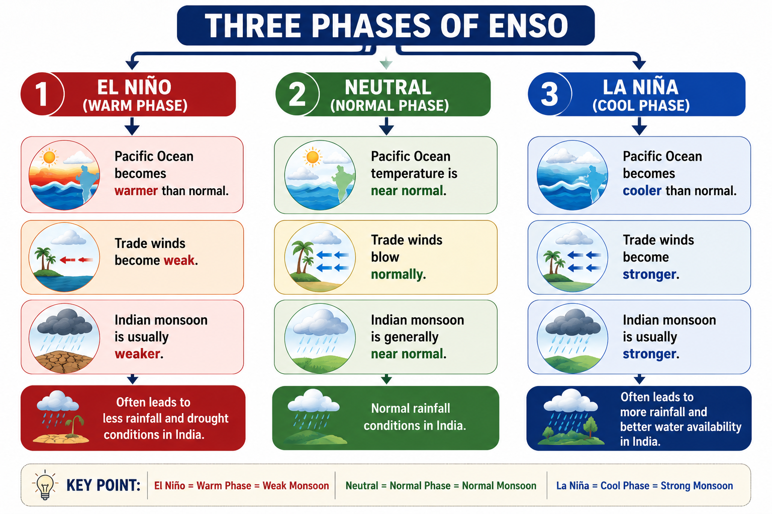
1. El Nino Southern Oscillation (ENSO):
ENSO (El Niño–Southern Oscillation) is a natural ocean–atmosphere phenomenon in the tropical Pacific Ocean that changes sea surface temperatures, air pressure, and winds.
These changes influence global weather patterns, including rainfall, temperature, and the Indian monsoon.
2. Indian Ocean Dipole (IOD)
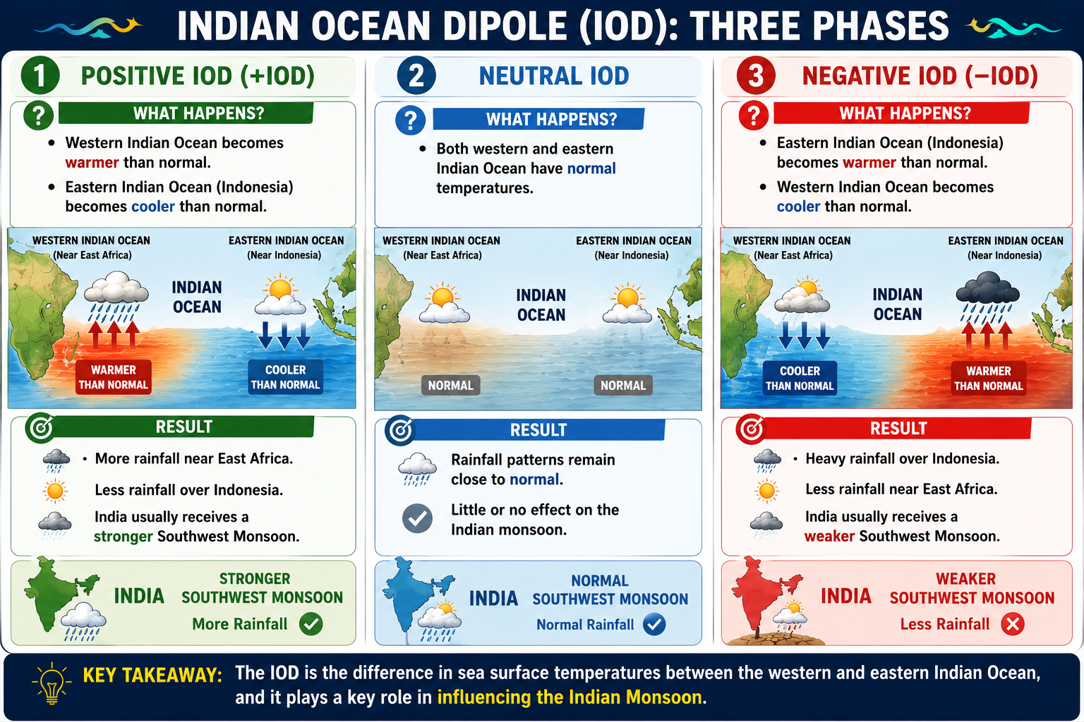
The Indian Ocean Dipole (IOD) is a climate phenomenon in the Indian Ocean in which the sea surface temperatures (SSTs) of the western and eastern Indian Ocean become different from each other.
The word Dipole means "two poles" or "two opposite regions."
There are two regions:
-
Western Indian Ocean (Near East Africa)
-
Eastern Indian Ocean (Near Indonesia)
Scientists compare the temperatures of these two regions.
Previous Year Questions:
1. La Nina is suspected to have caused recent floods in Australia. How is La Nina different from El Nino? (2011 Prelims)
-
La Nina is characterized by unusually cold ocean temperature in the equatorial Indian Ocean whereas El Nino is characterized by unusually warm ocean temperature in the equatorial Pacific Ocean.
-
El Nino has adverse effect on south-west monsoon of India, but La Nina has no effect on monsoon climate.
Which of the statements given above is/are correct?
(a) 1 only
(b) 2 only
(c) Both 1 and 2
(d) Neither 1 nor 2
Answer: (d)
2. The seasonal reversal of winds is the typical characteristic of (2014 Prelims)
(a) Equatorial climate
(b) Mediterranean climate
(c) Monsoon climate
(d) All of the above climates
Answer: (c)
3. With reference to ‘Indian Ocean Dipole (IOD)’ sometimes mentioned in the news while forecasting Indian monsoon, which of the following statements is/are correct? (2017 Prelims)
-
The IOD phenomenon is characterized by a difference in sea surface temperature between the tropical Western Indian Ocean and the tropical Eastern Pacific Ocean.
-
An IOD phenomenon can influence an El Nino’s impact on the monsoon.
Select the correct answer using the code given below:
(a) 1 only
(b) 2 only
(c) Both 1 and 2
(d) Neither 1 nor 2
Answer: (b)
4. Consider the following statements: (2015 Prelims)
-
The winds which blow between 30° N and 60° S latitudes throughout the year are known as westerlies.
-
The moist air masses that cause winter rains in the North Western region of India are part of westerlies.
Which of the statements given above is/are correct?
(1) 1 only
(2) 2 only
(3) Both 1 and 2
(4) Neither 1 nor 2
Answer: (b)