Extreme Flooding in India: A Comprehensive Study of Assam, Tripura, Wayanad, and Manipur
Flooding is a recurring natural disaster in India, particularly affecting states like Assam, Tripura, Wayanad (Kerala), and Manipur due to their geographic and climatic conditions. These floods not only result from excessive rainfall but are also exacerbated by deforestation, unregulated urban development, and climate change. The impact is profound, causing loss of life, displacement of communities, and severe damage to infrastructure and agriculture. While government interventions include both emergency relief and long-term resilience programs, challenges persist in terms of infrastructure, coordination, and preparedness. This detailed analysis explores the causes, consequences, and responses to flooding in each region, backed by scholarly references and reliable sources.
Causes of Extreme Flooding
Assam:
The primary cause of flooding in Assam is the annual monsoon, which leads to the swelling of the Brahmaputra River and its tributaries. The Brahmaputra, one of the largest rivers in the world, has a dynamic and unpredictable flow that often breaches embankments, inundating surrounding areas. Climate change has intensified this phenomenon, increasing both the frequency and volume of rainfall. The topography of Assam, with its low-lying floodplains, naturally makes the region prone to flooding. However, human factors such as deforestation, encroachments in floodplains, and poor urban drainage systems have worsened the situation. Guwahati, the state's largest city, frequently experiences urban flooding due to clogged drains and inadequate waste management, which prevent rainwater from draining effectively. Additionally, the construction of embankments, intended to control floods, has altered the river’s natural flow, sometimes causing more severe flooding when these structures are breached.
Tripura:
Tripura's hilly terrain, combined with heavy monsoon rains, results in flash floods that rapidly inundate valleys and low-lying areas. The Howrah and Katakhal rivers often overflow during periods of intense rainfall, submerging surrounding regions. Deforestation is a significant contributing factor, as the loss of forest cover reduces the soil’s capacity to absorb water, increasing surface runoff. Additionally, soil erosion caused by deforestation and agricultural activities leads to sediment deposition in rivers, reducing their water-holding capacity. Unplanned urban development, particularly in Agartala, has further disrupted natural drainage patterns, exacerbating the impact of floods. Climate change has also played a role, with rising temperatures leading to more intense and unpredictable rainfall patterns.
Wayanad (Kerala):
Wayanad, located in the Western Ghats, faces a dual threat of floods and landslides during the monsoon season. The region's steep slopes and heavy rainfall create ideal conditions for landslides, which can block rivers and create temporary dams that lead to sudden, severe flooding when they burst. Climate change has increased the intensity and duration of rainfall, as evidenced by recent events where rainfall levels were found to be approximately 10% heavier due to global warming. Deforestation, particularly for agriculture and plantation crops, has reduced the soil’s ability to retain water, increasing the risk of both floods and landslides. Unregulated construction on hillsides has further destabilized the region, while poor land-use planning has led to the development of settlements in flood-prone areas. The largest recorded landslide in India’s history occurred in Wayanad, displacing millions of cubic meters of debris and causing widespread destruction.
Manipur:
Flooding in Manipur is primarily caused by heavy rainfall during the monsoon season, which leads to the overflow of rivers such as the Imphal, Iril, and Nambul. The hilly terrain of the state contributes to rapid surface runoff, which can overwhelm river systems and cause flash floods. Deforestation in the hill regions has increased the volume and velocity of water flow, while soil erosion has led to the deposition of sediments in rivers, reducing their capacity to hold water. In urban areas such as Imphal, unplanned development and inadequate drainage systems contribute to flooding by preventing rainwater from draining naturally. Climate change has intensified these problems, with rising temperatures leading to more intense rainfall events. Additionally, poor maintenance of embankments and water channels has reduced the state’s ability to manage floodwaters effectively.
Impact of Extreme Flooding
The impact of flooding in these regions is both immediate and long-lasting, affecting not only the local population but also the environment and economy.
Human Displacement and Loss of Life:
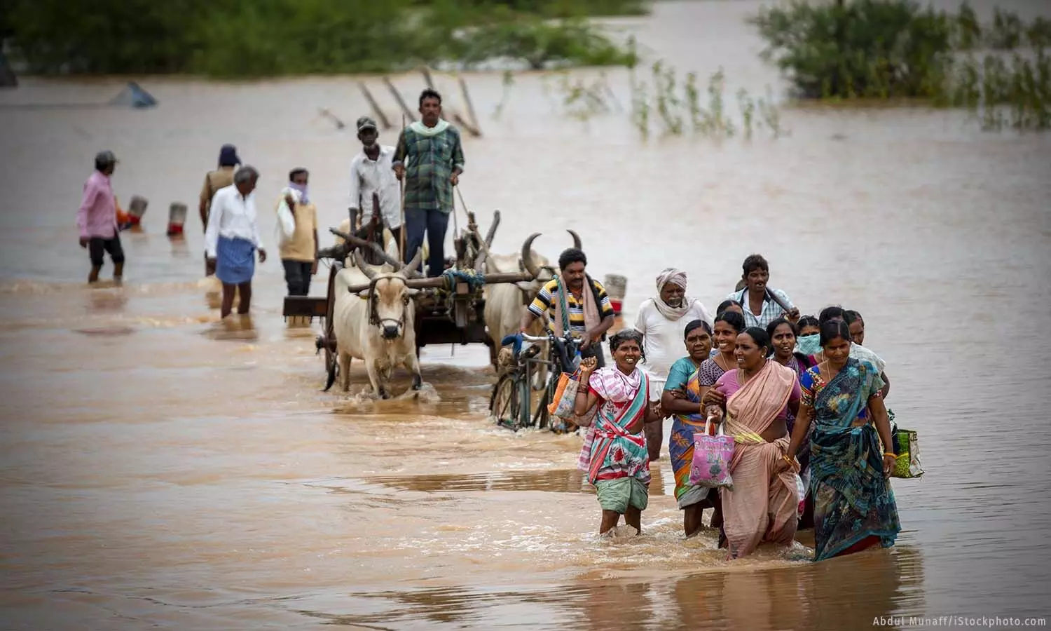
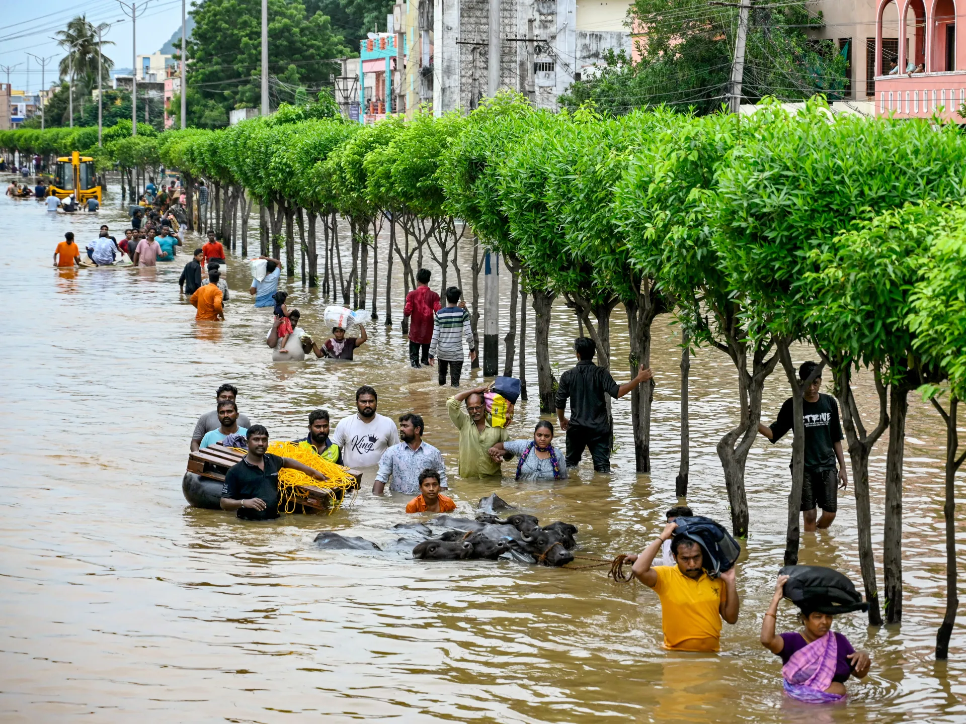
Floods in Assam have displaced over two million people in recent years, forcing many to seek refuge in overcrowded relief camps. Manipur and Tripura have also experienced widespread displacement, with entire communities being forced to abandon their homes. In Wayanad, landslides triggered by heavy rainfall have caused significant loss of life, with the largest recorded landslide in India’s history displacing entire villages.
Damage to Infrastructure:
Floodwaters have damaged roads, bridges, and buildings, disrupting transportation and communication networks. In Assam, flooding has repeatedly damaged embankments, roads, and railways, hampering both rescue operations and economic activities. In Tripura and Manipur, landslides and flash floods have damaged hill roads, making it difficult to deliver aid to affected areas. In Wayanad, landslides have destroyed homes and infrastructure, isolating communities and making rescue operations challenging.
Agricultural Losses:
Flooding has severely impacted agriculture, which is the primary livelihood for many people in these regions. In Assam, floodwaters submerge rice fields and destroy crops, reducing both yield and income for farmers. Tripura and Manipur face similar challenges, with flash floods washing away crops and damaging soil quality. In Wayanad, landslides have destroyed agricultural land, while prolonged waterlogging has damaged plantations of coffee, tea, and spices, which are essential to the local economy.
Environmental Degradation:
Flooding and landslides have led to soil erosion, loss of forest cover, and contamination of water sources. In Assam, the erosion of riverbanks has resulted in the loss of agricultural land and habitats for wildlife, particularly in areas near the Kaziranga National Park. In Wayanad, landslides have altered the natural landscape, while deforestation has reduced biodiversity and increased the risk of future floods. In Manipur and Tripura, soil erosion has degraded both agricultural land and river ecosystems, reducing their ability to support plant and animal life.
Government Response and Challenges
Immediate Relief Efforts:
The state governments, with support from the National Disaster Response Force (NDRF) and local agencies, conduct rescue operations and provide emergency relief to affected communities. Evacuation efforts focus on moving people from flood-prone areas to safer locations, while relief camps offer food, clean water, and medical care. However, overcrowding and limited resources often make it difficult to meet the needs of all displaced people. In some cases, logistical challenges and damaged infrastructure have delayed the delivery of aid.
Long-term Resilience and Mitigation:
Governments at both the state and national levels are implementing measures to reduce the impact of future floods. In Assam, initiatives include improving flood forecasting systems, strengthening embankments, and restoring wetlands to absorb excess water. Efforts to reforest degraded areas aim to reduce soil erosion and increase water retention. Tripura and Manipur are focusing on improving drainage systems in urban areas and promoting sustainable land-use practices in hill regions. In Wayanad, authorities are regulating construction in ecologically sensitive areas and promoting sustainable agriculture to reduce soil erosion.
Climate Change Adaptation:
Recognizing the role of climate change in increasing flood risks, governments are integrating climate resilience into their disaster management plans. This includes developing early warning systems that can provide timely alerts to at-risk communities, as well as building infrastructure that can withstand extreme weather events. In Assam, climate resilience programs focus on both urban and rural areas, with an emphasis on reducing the impact of river flooding. Wayanad is implementing measures to mitigate the impact of heavy rainfall and prevent landslides, including reforestation and improved land-use planning.
Challenges and Limitations:
Despite these efforts, several challenges remain. Inadequate infrastructure, including aging embankments and poorly maintained drainage systems, limits the effectiveness of flood control measures. Coordination between state and central governments is sometimes delayed, affecting both emergency response and long-term planning. Limited financial resources and competing priorities also make it difficult to implement large-scale mitigation projects. Additionally, unregulated urban development and deforestation continue to increase flood risks, highlighting the need for stricter enforcement of environmental regulations.
Flooding in Assam, Tripura, Wayanad, and Manipur is a complex issue driven by both natural and human factors. While heavy rainfall and the region’s geography make these areas naturally prone to flooding, climate change, deforestation, and unplanned development have significantly worsened the situation. The impact of flooding is severe, displacing millions of people, damaging infrastructure, and disrupting agriculture. Government responses have included both emergency relief and long-term resilience measures, but challenges remain in terms of infrastructure, coordination, and preparedness. Addressing these challenges requires a comprehensive approach that integrates climate resilience, sustainable land use, and improved disaster management to reduce the impact of future floods.
Climate Resilience and Disaster Preparedness in Flood-Prone Regions of India
Floods in Assam, Tripura, Wayanad, and Manipur highlight the urgent need for comprehensive disaster management and climate resilience strategies. Given the increasing frequency and intensity of floods due to climate change, building resilience and improving preparedness are crucial. This section explores the disaster management frameworks in place, measures to enhance climate resilience, and strategies for improving disaster preparedness in these vulnerable regions.
Disaster Management
Disaster management in India is governed by the Disaster Management Act of 2005, which established the National Disaster Management Authority (NDMA) to oversee disaster prevention, mitigation, and response. Each state has its own State Disaster Management Authority (SDMA), responsible for implementing disaster management plans tailored to local risks.
Key Components of Flood Disaster Management:
- Risk Assessment and Mapping:
- Identifying flood-prone areas using Geographic Information Systems (GIS) and remote sensing technology.
- Mapping vulnerable populations, infrastructure, and critical facilities to prioritize risk reduction measures.
- Flood Forecasting and Early Warning Systems:
- The Central Water Commission (CWC) operates flood forecasting stations that monitor river levels and predict floods.
- Real-time data from weather agencies, such as the India Meteorological Department (IMD), is used to issue early warnings to communities.
- Structural Mitigation Measures:
- Constructing and maintaining embankments, dams, and reservoirs to control river flow and reduce flood risk.
- Improving urban drainage systems to prevent waterlogging in cities like Guwahati and Imphal.
- Building flood-resistant infrastructure, including elevated roads, bridges, and homes.
- Non-Structural Mitigation Measures:
- Implementing land-use regulations to prevent construction in flood-prone areas, particularly in Wayanad’s hilly terrain.
- Promoting afforestation and sustainable agriculture to reduce soil erosion and improve water absorption.
- Conducting awareness campaigns to educate communities about flood risks and preparedness measures.
- Emergency Response and Relief:
- Deploying the National Disaster Response Force (NDRF) and State Disaster Response Forces (SDRF) for search and rescue operations.
- Establishing temporary relief camps with food, clean water, and medical care for displaced populations.
- Providing financial assistance and rebuilding support to affected families.
Climate Resilience
Climate resilience refers to the ability of communities and ecosystems to withstand and adapt to the impacts of climate change. Given that climate change has intensified rainfall patterns and increased flood frequency, building resilience is essential to reduce long-term risks.
Key Climate Resilience Strategies:
- Integrating Climate Change into Disaster Planning:
- Climate risk assessments are integrated into state disaster management plans to account for future changes in rainfall patterns and flood risks.
- Infrastructure projects, such as dams and embankments, are designed to withstand extreme weather events, ensuring long-term resilience.
- Nature-Based Solutions:
- Restoring wetlands and floodplains to absorb excess water and reduce flood severity. For example, Assam is working to restore wetlands around the Brahmaputra River.
- Reforestation programs in Manipur and Tripura aim to reduce soil erosion and improve water retention in hill regions.
- Promoting sustainable agriculture and agroforestry in Wayanad to enhance soil health and reduce landslide risks.
- Community-Based Adaptation:
- Empowering local communities to assess their own risks and implement climate-resilient practices.
- Providing training on flood preparedness, including evacuation procedures and first aid.
- Supporting alternative livelihoods that are less vulnerable to floods, such as aquaculture and flood-resistant crops.
- Climate-Resilient Infrastructure:
- Building elevated homes and flood shelters in vulnerable areas to protect residents from rising waters.
- Designing roads, bridges, and other infrastructure to withstand heavy rainfall and waterlogging.
- Upgrading urban drainage systems in cities like Guwahati and Imphal to handle increased rainfall.
- Policy and Governance:
- Strengthening environmental regulations to prevent deforestation and unregulated construction in flood-prone areas.
- Encouraging sustainable land-use practices that reduce flood risks, such as maintaining green spaces and preserving natural water channels.
- Establishing climate resilience committees at the district and village levels to ensure local participation in adaptation efforts.
Disaster Preparedness
Disaster preparedness involves proactive measures to ensure that communities and governments can respond quickly and effectively when floods occur. This reduces the impact on human life, infrastructure, and livelihoods.
Key Elements of Flood Preparedness:
- Early Warning Systems:
- Expanding the use of weather radars and satellite technology to improve rainfall predictions and flood forecasts.
- Using mobile phones, radio, and social media to deliver early warnings directly to communities.
- Developing community-based early warning networks, particularly in remote areas with limited communication infrastructure.
- Emergency Preparedness Plans:
- Developing detailed evacuation plans that identify safe routes and shelters for flood-prone areas.
- Conducting regular flood drills in schools, hospitals, and communities to ensure everyone knows how to respond.
- Establishing emergency response teams at the village and district levels, trained in search and rescue, first aid, and disaster management.
- Community Involvement and Capacity Building:
- Training local volunteers to assist with evacuation, rescue, and relief efforts during floods.
- Educating communities about flood risks, emergency procedures, and the importance of early evacuation.
- Providing resources such as emergency kits, boats, and life jackets to communities in high-risk areas.
- Infrastructure and Resource Readiness:
- Pre-positioning emergency supplies, including food, water, and medical kits, in flood-prone areas.
- Ensuring that flood shelters are equipped with essential amenities and can accommodate large numbers of people.
- Maintaining rescue equipment, boats, and vehicles to ensure they are ready for use during emergencies.
- Post-Flood Recovery and Rehabilitation:
- Developing recovery plans that prioritize rebuilding infrastructure and restoring livelihoods.
- Providing financial assistance and low-interest loans to help families rebuild their homes and businesses.
- Offering mental health support to help individuals cope with the trauma of flooding and displacement.
Region-Specific Preparedness and Resilience Measures
Assam:
- Expanding flood forecasting systems along the Brahmaputra River to provide more accurate and timely warnings.
- Strengthening embankments and restoring wetlands to reduce the impact of river flooding.
- Training local communities in flood preparedness and evacuation procedures.
Tripura:
- Improving drainage systems in urban areas like Agartala to prevent waterlogging during heavy rainfall.
- Reforesting hill regions to reduce soil erosion and improve water retention.
- Conducting flood drills and awareness campaigns in schools and communities.
Wayanad (Kerala):
- Regulating construction in ecologically sensitive areas to reduce the risk of landslides.
- Promoting sustainable agriculture and agroforestry to improve soil health and reduce runoff.
- Developing community-based early warning systems for both floods and landslides.
Manipur:
- Improving drainage systems in urban areas like Imphal to prevent waterlogging.
- Reforesting hill regions to reduce soil erosion and improve water absorption.
- Strengthening embankments and maintaining water channels to prevent river overflow.
Building climate resilience and improving disaster preparedness are essential to reducing the impact of flooding in Assam, Tripura, Wayanad, and Manipur. While significant progress has been made in terms of flood forecasting, emergency response, and infrastructure development, challenges remain in terms of coordination, funding, and enforcement of environmental regulations. Strengthening early warning systems, promoting sustainable land use, and empowering local communities are key to building long-term resilience. By integrating climate change adaptation into disaster management plans and investing in both structural and non-structural measures, India can reduce the vulnerability of flood-prone regions and ensure the safety and well-being of its citizens.
(References used for this section include government reports from NDMA, CWC, and IMD, as well as articles from Drishti IAS, Business Standard, BBC News, Open Contracting Partnership, Down to Earth, and Asia Sentinel.)