
Char Dham Yatra - Helicopter Accidents
Syllabus Areas:
GS I - Geography
GS II - Governance
GS III - Disaster Management
General Essay
A helicopter operated by Aryan Aviation crashed near Kedarnath on June 15, 2025, killing all seven people on board, including a retired Indian Army pilot and a two-year-old child. This was one of nearly 8,789 helicopter trips flown in just 45 days of the Char Dham Yatra season, highlighting the intense air traffic in a highly sensitive and dangerous zone.
What is char Dham Yatra?
The Char Dham Yatra refers to the sacred pilgrimage to four major Hindu shrines located in the Indian Himalayas of Uttarakhand. These four shrines are:
- Yamunotri – Source of River Yamuna
- Gangotri – Source of River Ganga
- Kedarnath – Dedicated to Lord Shiva (one of the 12 Jyotirlingas)
- Badrinath – Dedicated to Lord Vishnu (part of original Char Dham by Adi Shankaracharya)
Location:
All four shrines are located in the Garhwal region of Uttarakhand, at high altitudes ranging from 3,000 to 3,500 metres above sea level.
High-Risk Flying Conditions in the Himalayas
- The crash occurred at around 11,500 feet above sea level, where unpredictable weather conditions and narrow flight corridors make helicopter operations extremely dangerous.
- On the morning of the crash, visibility in the Kedarnath valley suddenly dropped to just a few metres due to dense cloud formation, making safe flying nearly impossible.
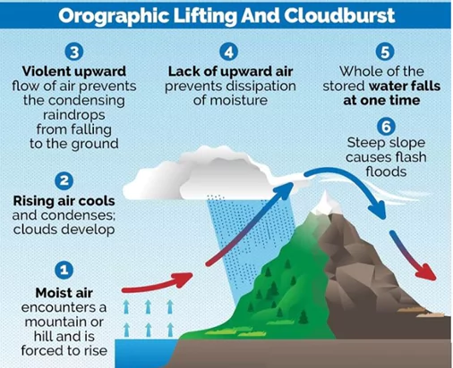
- Pilots face constant threats from sudden weather shifts such as the “Rambara Express” — a cloudburst phenomenon caused by orographic lifting — which forms rapidly and leads to white-outs.
What is Cloudburst?
A cloudburst is an extreme weather event where a sudden, intense rainfall occurs in a short period, typically over a localized area, often leading to flash floods and widespread damage, especially in mountainous regions.
Causes of Cloudburst?
Orographic Lifting: Moist air is forced to rise rapidly due to mountain slopes, cooling and condensing quickly to form intense rainfall.
Convection: Strong vertical air currents in the atmosphere (especially during monsoon) cause rapid cloud formation and precipitation.
Presence of Cumulonimbus Clouds: These are large, towering clouds associated with thunderstorms and heavy rainfall.
Favorable Conditions:
Occur mostly in Himalayan regions (e.g., Uttarakhand, Himachal Pradesh, Ladakh).
Common during monsoon season (June–September).
Occur without much warning due to localized nature and lack of real-time forecasting infrastructure.
GS I 2024 Mains Question:
Q. What is the phenomenon of 'cloudbursts'? Explain. 150 Words, 10 Marks
- The lack of visibility and the absence of navigational support make flying in this region as much a matter of instinct and familiarity as of skill and regulation.
Absence of Basic Aviation Infrastructure
- Despite handling over 250 sorties per day during peak season, the Kedarnath route lacks even the most fundamental aviation infrastructure like radar coverage, air traffic control (ATC), and aviation-grade weather stations.
- Pilots operate solely under Visual Flight Rules (VFR), using radio communication and personal experience for navigation and hazard detection.
- In such conditions, even minor lapses can lead to catastrophic consequences, as pilots cannot rely on instruments or external guidance for safe operations.
Overburdened Helicopter Operations Due to Pilgrimage Demand
- The Char Dham Yatra, especially Kedarnath, has seen a surge in helicopter traffic, with operators flying from early morning until late evening to meet pilgrim demands.
- Earlier, a helicopter was allowed only eight trips a day, but in recent years, this cap has been ignored, leading to fatigue among pilots and compromised safety standards.
- Helicopters often do not land fully during shuttle services; instead, passengers are rushed in and out while the blades are still running, reducing turnaround time but increasing operational risks.
Evolution of Pilgrimage Accessibility and Commercialisation
- Traditionally, the journey to Kedarnath was a 16-km trek from Gaurikund through rugged Himalayan terrain, demanding physical and mental endurance from pilgrims.
- Since 2003, government-run helicopter services like Pawan Hans have offered limited flights to elderly and disabled pilgrims.
- By 2006, regular shuttle services began, and the establishment of the Uttarakhand Civil Aviation Development Authority (UCADA) in 2013 further boosted commercial operations.
- Today, over nine private companies operate flights with fares ranging between ₹5,000–₹7,000 for return trips, while full Char Dham charter packages cost up to ₹1.5 lakh per person.
HELICOPTER ACCIDENTS IN RECENT PAST
- JUNE 15, 2025: Aryan Aviation chopper crashes in Kedar valley, killing all seven on board, including pilot you
- JUNE 7, 2025: A Kestrel Aviation chopper carrying six pilgrims makes emergency landing on a highway in Rudraprayag
- MAY 8, 2025: Aero Trans Service Pvt Ltd chopper crashes in Gangnani near Kedarnath, killing 5 pilgrims and pilot
- APRIL 23, 2023: Uttarakhand civil aviation authority's finance controller dies after being hit by tail rotor while boarding chopper at Kedarnath
- OCT 18, 2022: Aryan Aviation chopper crashes near Kedarnath, killing 6 pilgrims and the pilot.
Regulatory Failures and Safety Violations
- The current operations reveal systematic gaps in regulatory oversight and enforcement of safety standards.
- The Directorate General of Civil Aviation (DGCA) ordered a safety audit only after multiple crashes occurred, exposing its reactive approach.
- There is immense pressure on pilots and operators to maximize the limited flying window, often leading to disregard for safety protocols and weather warnings.
- The absence of mandatory pre-flight checks and location-specific weather assessments further compounds the danger.
Recent Governmental Responses and Proposed Reforms
- After the June 15 crash, DGCA capped flight frequency to 9 per hour, down from an unrestricted earlier count, to reduce airspace congestion.
- The Uttarakhand government and UCADA are setting up a command-and-control centre to track helicopter movement in real time and improve situational awareness.
- An ATC system is being developed at Sahastradhara heliport in Dehradun, and more real-time weather cameras are being installed in Kedarnath valley.
- New protocols are being drafted to mandate strict pre-flight safety checks, precise weather monitoring, and pilot qualification standards for high-altitude operations.
Prelims Questions:
- Which of the following factors contribute to the high risk
associated with helicopter operations during the Char Dham Yatra in the
Kedarnath
region?
- Sudden weather changes due to orographic lifting
- Lack of radar and air traffic control infrastructure
- Increased flight frequency without strict regulations
- Presence of high-altitude runways with advanced navigational systems
- 1, 2 and 3 only
- 1 and 4 only
- 2, 3 and 4 only
- 1, 2, 3 and 4
- What regulatory response was immediately implemented by the
Directorate General of Civil Aviation (DGCA) following the June 15, 2025
Kedarnath
helicopter crash?
- Banned all helicopter flights for the next Char Dham season
- Reduced the maximum number of helicopter flights to 9 per hour
- Nationalized all helicopter operations to control safety violations
- Shifted the Char Dham Yatra route to fixed-wing aircraft only
- The phenomenon termed “Rambara Express” or “Mandakini
Express” mentioned in the context of the Kedarnath helicopter crashes is
associated with:
- Rapid formation of glacier crevasses
- Sudden cloud surges caused by orographic lifting
- Landslide-triggered air vortices in valleys
- Tsunami-like air displacement in high-altitude valleys
Select the correct answer using the code below:
Answer: A
Explanation: Point 4 is incorrect because the region lacks advanced navigational systems.
Answer: B Explanation:
DGCA capped helicopter frequency to 9 per hour to reduce congestion and improve safety.
Answer: B Explanation:
The "Rambara Express" is a sudden cloud formation caused by orographic lifting, leading to white-out conditions.
Mains Question:
- Critically examine the challenges and suggest measures to ensure safe and sustainable aviation operations in ecologically fragile zones. 150 words 10 Marks